The marine biology community and the dive industry have some Citizen Science projects as well. ConnectOcean work hard on a few of them. We also initiated some projects. More about them later. We have a multitude of projects that all
fit together like a jigsaw puzzle! Our projects engage participants with
hands-on place-based learning through data collection aimed towards
conservation of our oceans.
One of the projects
is the Marine life census. In this
project, we collect data through roving fish surveys, Baited Remote Underwater
Video Stations (BRUVS) and laser photogrammetry units. The Baited Remote
Underwater Video Station is Video Station who is placed on the bottom of the
ocean or free flowed in midwater or nearly on the surface. The Camera is
focused on the bait and records all kind of fish who come and investigate the
station. Back in the office we review the footage and count all fish by species
in the video. This information is really valuable for us because it tells us
which species are living in this area and how many they are. And this without
disturbing the fishes. We try to use the station as often as possible and send
it out on the different dive sites while we are diving.
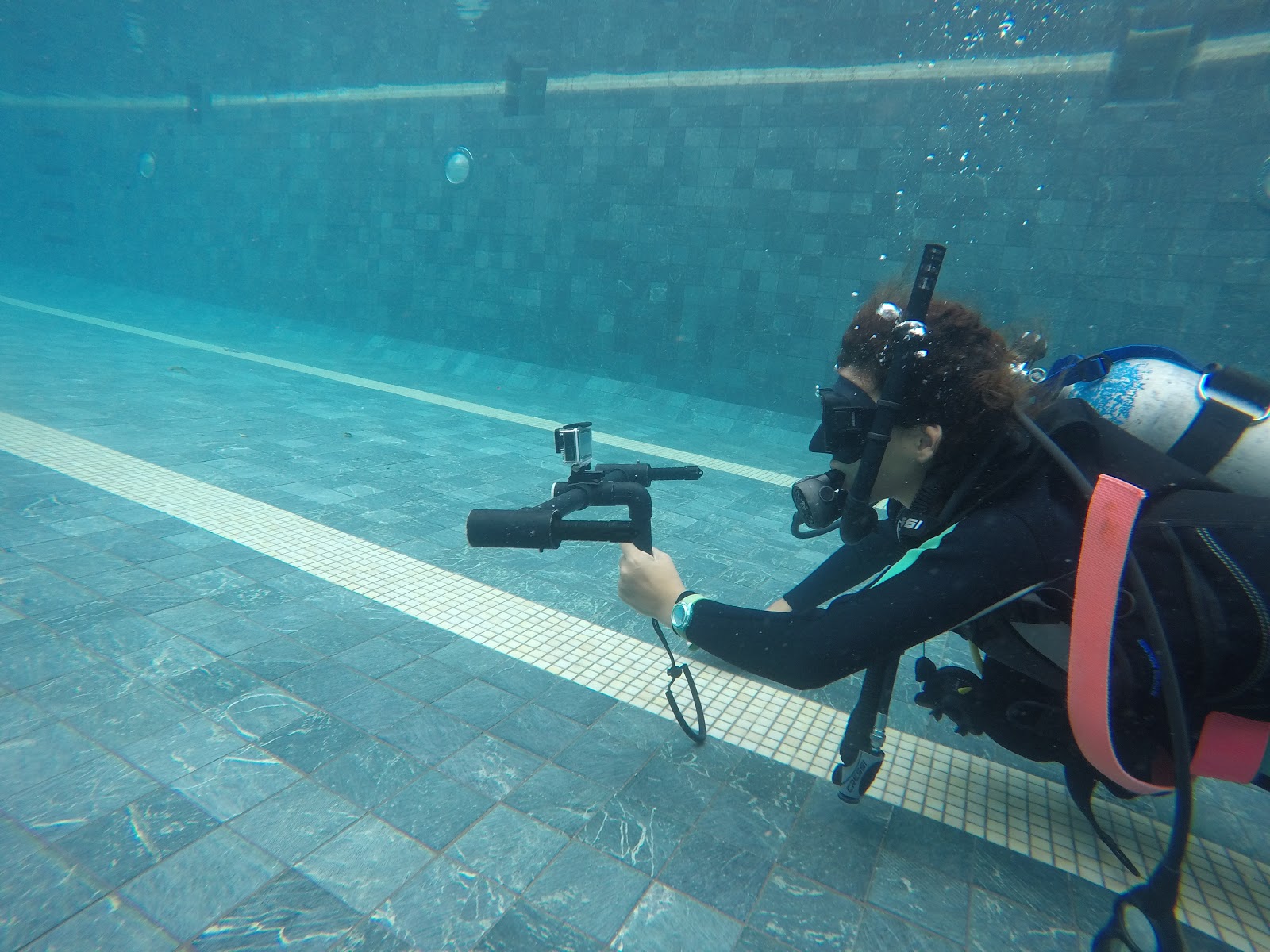
We use the
laser photogrammetry units to measure sharks, rays, and turtles. The Laser
photogrammetry unit is designed by our partners at Ocean First Institute. The
laser dots accurate a frame of calibrated 50 cm. We can record these laser dots
with a Go-Pro Camera and process the footage afterword in the office. For
example, to measure a shark, point them to two laser dots in a 90° angle on the
shark and records this with the Go-Pro. Back in the office upload the footage
on your computer and start the measuring software. With this software is it now possible to
measure the shark on the non-invasive way. We try to bring the laser units to
every dive and collect as much data as possible. If you dive with ConnectOcean,
you get the possibility to help in a Citizen Science Project and can help us measure sharks and rays and conduct a roving fish survey.
The Photo ID database of Oceanic Manta Rays
Project is a project where we collaborate with MantaTrust. ConnectOcean is Costa
Rica’s regional liaison MantaTrust. The general idea is to upload pictures of
Oceanic Manta Rays from all over the world in a database. Oceanic Manta Rays
have unique markings on their abdomen, like a fingerprint. This fact allows us
to identify and track individuals. The logarithm in a software helps us to
identify individuals through "face perception" with their marks on
their abdomen. It allows us, when divers from all over the world upload their
pictures from Oceanic Manta Rays, to follow the individuals and learn more
about their movement and their migration. We collect as much data as possible
from the dive center up and down the Costa Rica's Pacific Coast to populate the
database we house and update.
We also collect data on Vessels and user groups of
the waters surrounding the Las Catalinas Islands. We try to write down and
identify all types of vessel that we see during our dives in this region. For
example, how many fishing boats can we spot and what kind of fishing boat is it?
Is it a commercial fishing boat with longlines or is it a small artisinal fishing boat owned
by a local fisherman? By layering the data from our fish surveys and vesselsurveys and combining the results we can see correlations and maybe draw some conclusions. For example, if
we don’t spot any sharks in a particular area but many longline fishing boats,
we can interpret it as the fishing boats fishing for the sharks. This knowledge
gives us the opportunity to talk with the fishermen from the community and we may
be able to negotiate with them for temorary non-fishing areas to protect the
species in there, so they have the chance to multiply themselves again and restore the population.
We work on an application where all this
Citizen Science Project get combined. The generation from today spends so much
time on their smartphone. If we want attention from this generation and
engage them in these issues we have to keep up with the time. The idea is to
build an application that everybody can download for a small amount of money.
With this money future project can be financed. The application is divided in
four topics. Photo ID for Oceanic Manta rays, Collecting Data on vessels, Laser
photogrammetry, and Marine life census. Anyone who has downloaded the
application can now collect data and upload the pictures and counts. All these
information helps us, to understand more about the marine life and why at some
places just a small amount of fish can be found. With all these data and
together with the local community, we may be able to build a marine reserve like Mexico’s
Cabo Pulmo and protect the local marine life.
The Citizen
Science Projects initiated by ConnectOcean are 5 place-based learning
excursions to engage participants of all ages.
1) Sources of the sea – During this excursion the participants explore the rivers and looking
for macro invertebrate indicator species. We start Program in the Monte Verde Cloud
Forest and follow the rivers down to the Guanacaste Coast.
2) Intertidal Explorer – In this course the participants learn more about the five tidal zones
(splash zone, high tide zone, mid tide zone, low tide zone and submerge zone)
and the different species who live in the different zones. Part of the course
is as well to investigate the species with microscopes and magnifying glasses.
So, you get a closer look at these fascinating animals and their adaption to their environment. We also talk about the challenges and benefits of living in each
zone.
3) Mangrove Explorer – This course is linked to the Source of Sea Course. Because the rivers
who are coming from the mountains cross the Mangrove Forests before entering
the sea. In this course, we take small river boats and explore and experience
the mangroves. During this trip the participants learn more about the
importance of the mangroves. On one hand, the mangroves buffers storms and
flooding who comes from the ocean and on the other hand the mangroves and their
root system creating a nursery habitat for marine species to grow.
4) Reef Explorer
– The participants will go snorkeling in this course and explore the Reefs next
to the beach. Here in Costa Rica, we don't have the typical coral reefs, they
are made up of volcanic rocks. It is a habitat for a few species of corals as
well as coralline algae. During this course, we learn more about the species
who live in this area and how they interact to create a unique ecosystem.
5) Open Ocean Explorer – Even though the ocean covers 71% of the Earth’s surface and it makes
99% of the earth’s living place, only 10% has been explored by humans. In this
course, we dive into the depths to see and track species and learn more about
their interesting adaption they use to survive. We discuss ocean life and
migratory species. And we can combine this course with a laser photogrammetry
dive and measure sharks and rays.
Through all these courses a bunch of data
can be collected for these different ecosystems. And all this without special
skills or specific knowledge. And data collection has never been so much fun as with
these projects. During these courses, you learn more about the different
ecosystems get to experience amazing environments and at the same time you help to protect them. That's just
great.
During our
internship here with ConnectOcean, we are involved in all these projects. And we
help to teach the participants. But to be able to teach, first, we have to
learn more about these ecosystems. We join all the lessons from our Instructors
when they are teaching to listen and to learn. Like with the kids from Futuro Brillantes who did the intertidal explorer (see the post before).
On the majority of our dives we bring laser photogrammetry units. We have learned how to handle and prepare the units, and how to
control and calibrate the laser dots. One day we went with clients to Las Catalinas Islands to measure sharks and rays. The clients did this dive as
part of the citizen's science program. On the dives we saw a guitar shark,
different types of rays and seven whitetip reef sharks. We were able to measure
some of them, and that is what we try to do on most of our dives.
We also showed them how to use the laser photogrammetry
unit. We did an exercise where the students had so measure a shark in the pool. Since there are no sharks in our pool, Matthias acted as shark for the students and
they tried to measure him with the laser photogrammetry unit. After the pool
session, we uploaded our footage on the computer and measured Matthias body
size.

The students saw how important it is to measure in a 90° angle and that it can be very difficult to see the laser dots in the video. But they goy super excited to try it out on a real shark in the ocean.
One week later they got that opportunity. When we went diving to complete their Ocean Explorer course together with their Shark Aware Speciality Course we encountered several white tip reef sharks and the students got the opportunity to measure them. It was such a memorable experience and hopefully they now have more knowledge about why it's important and how to protect the apex predators of our oceans; our friends, the sharks.
After two successful dives we had happy students and four new certified Ocean Explorer Level 2 divers!

No comments:
Post a Comment